Smart Farming Drones: What They Actually Do on a UK Farm
A Field-Level View of Drone Work
Walking a wet headland in February, you notice the usual things: rutted tracks, a gate that needs rehanging, and above you, a faint hum that is not a tractor. That hum is a drone doing a late-winter field survey, mapping drainage patterns and picking out areas where the crop is struggling. It is a common sight now, and for good reason. Smart farming drones have moved from novelty to a standard tool on many British farms, and the shift is not about gadgets. It is about doing the same job with better information.
Seeing What the Eye Misses
The real value starts with remote sensing. A standard camera on a drone captures visible light, but the more useful work happens in the near-infrared spectrum. That is where NDVI comes in. By measuring how strongly a crop reflects light, NDVI gives a precise picture of plant health, vigour, and stress. You can spot a failing patch of wheat weeks before it shows up as yellowing in the field. That early warning changes how you manage inputs.
I remember a farm near York where the grower used a drone to survey a 200-acre block of winter wheat. The NDVI map showed a clear stripe of poor growth running diagonally across the field. The initial thought was a soil issue, but the drone data, combined with a soil scan, revealed a buried land drain that had collapsed. No amount of walking the field would have shown that pattern so clearly. That is the kind of insight that makes smart farming drones worth the investment.
From Maps to Action: Variable Rate Application
Mapping is only half the story. The other half is acting on the data. This is where variable rate application comes in. Instead of spreading a uniform rate of fertiliser across the whole field, you use the drone maps to create a prescription. Areas with high NDVI get less nitrogen; stressed zones get more. The same logic applies to seed sowing and crop protection products.
One of the most practical uses I have seen is with a granular spreader mounted on a drone. On a hilly field in the Cotswolds, a farmer used a drone spreader to apply slug pellets to a freshly drilled oilseed rape crop. Walking that ground with a hand spreader would have taken half a day and would have missed the steepest slopes. The drone covered it in less than an hour, and the GPS-controlled spreading meant every pass was exactly where it should be, with no overlaps or gaps.
Variable rate application is not just about saving money on inputs, though it does do that. It is about reducing the environmental footprint. Applying the right amount in the right place means less fertiliser runoff into watercourses, less pesticide drift, and a smaller carbon footprint from fewer tractor passes. That is a message that resonates with the National Farmers' Union and with Defra, both of which are increasingly focused on sustainable farming practices.
The Hardware and the Software
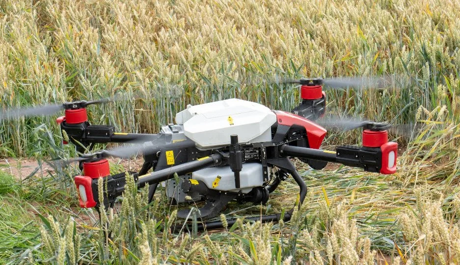
When people ask me which drone to look at, I usually mention the DJI Agras series. It is the workhorse of agricultural spraying, with a solid payload capacity and reliable flight characteristics. XAG is another name that comes up, particularly for larger operations, and their ground-based systems integrate well with drone data. For mapping, SenseFly and Parrot offer fixed-wing and multi-rotor options that are well suited to medium-sized farms. Each has its strengths, and the choice depends on whether you want to spray, spread, or simply survey.
But the hardware is only as good as the software that drives it. Flight planning software has come a long way. You can now set a field boundary, define the application rate, and let the system generate an efficient flight path that avoids obstacles and no-fly zones. The integration with a Geographic Information System, or GIS, means you can layer drone data with soil maps, yield history, and even weather data. That kind of layered analysis is where precision agriculture really starts to pay off.
Spraying and Spreading: The Practical Side
One of the most common questions I get is whether drones can replace tractors for spraying and spreading. The honest answer is that it depends. For small, awkward fields, or for spot treatments, a drone sprayer is hard to beat. You can target a specific weed patch without treating the whole field, which cuts chemical use and reduces the risk of resistance. But for broad-acre spraying over hundreds of hectares, a self-propelled sprayer is still faster and more cost-effective.
The sweet spot is in the middle. Many UK farms are using drones for the final pass in a cereal crop, where you want to avoid tractor wheelings and soil compaction. A drone can enter the crop without touching the ground, applying a fungicide or a growth regulator with precision. The same applies to fertiliser spreading. A granular spreader on a drone can place nitrogen exactly where it is needed, even in fields that are too wet to take a tractor without causing damage.
Seed Sowing and Crop Protection
Seed sowing is another area where drones are making inroads. In some parts of the UK, drones are used to sow cover crops into standing maize, a technique that saves time and protects the soil. The drone drops the seed into the crop canopy, where it germinates after harvest, providing a green cover over winter. It is a clever use of the technology, and it works well with small, lightweight seeds.
For crop protection, the precision of a drone sprayer can be a major advantage. The downwash from the rotors pushes the spray into the canopy, which can improve coverage on the underside of leaves, a common weakness with traditional sprayers. That is particularly useful for aphid control in sugar beet or for late-season blight in potatoes. The ability to apply a pesticide application exactly when and where it is needed, without waiting for the ground to dry, is a genuine benefit.
The Data Side: GPS, NDVI, and Decision Making
None of this works without good data. The Global Positioning System, or GPS, is the backbone of drone operations, providing the accurate positioning needed for consistent passes and for creating prescription maps. Without GPS, a drone is just a remote-controlled toy. With it, you get sub-metre accuracy, which is essential for variable rate application.
NDVI is one of the most widely used indices, but it is not the only one. There are other vegetation indices that can be more sensitive to specific stresses, such as nutrient deficiency or waterlogging. The key is to interpret the data in context. A single NDVI map can be misleading if you do not account for soil type, weather, and crop stage. That is where experience comes in. The best drone operators are not just pilots; they are agronomists who understand what the data means.
Regulation and Practical Considerations
Flying drones for commercial purposes in the UK is not a free-for-all. The Civil Aviation Authority, or CAA, requires operators to hold a valid qualification, usually the A2 Certificate of Competency or the General Visual Line of Sight Certificate. There are also restrictions on flying over people and property, and you must keep the drone within visual line of sight unless you have special permission. For agricultural work, that is usually not a problem, but it does mean you need to plan your flights carefully.
Defra has been supportive of drone use in agriculture, particularly in the context of sustainable farming incentives. The National Farmers' Union has also highlighted the potential for drones to reduce input costs and improve environmental outcomes. However, they also point out the need for clear regulation and training. It is not just about buying a drone; it is about understanding the rules and using the technology responsibly.
Costs and Return on Investment
Let us talk money. A decent agricultural drone, such as a DJI Agras T30 or a similar model from XAG, will set you back anywhere from £15,000 to £30,000, depending on configuration. That is a significant investment for a small farm. But the return can be substantial. Savings on fertiliser, pesticides, and seed, combined with reduced labour and fuel costs, can pay for the drone within a few seasons.
Take a typical 500-acre arable farm. If variable rate application reduces nitrogen use by 10 percent, that is a saving of around £5,000 a year. Spot spraying weeds instead of blanket spraying can save another £2,000. Add in the time saved by not having to walk fields for scouting, and the payback period shortens considerably. Many farmers also use drone data to negotiate better crop insurance rates, because they can prove they are managing risk more effectively.
The Human Element
For all the technology, the most important part is still the person making the decisions. A drone is a tool, like a plough or a sprayer. It does not replace the farmer's knowledge of their land, their crops, and their local conditions. What it does is give them better information to work with. That is the real promise of smart farming drones: not automation for its own sake, but better decision-making.
I have seen farmers who were initially skeptical of drones become converts after a single season. They realise that the drone is not a toy or a gimmick. It is a way to see the farm from a perspective that was previously impossible, and to act on that view with precision. That is what precision agriculture is all about, and it is why smart farming drones are here to stay.
If you are considering adding a drone to your farm, start small. Use a mapping drone to survey a few fields. Learn to interpret the NDVI maps. Talk to other farmers who are already using the technology. And when you are ready to move into spraying or spreading, choose a system that fits your scale and your crop types. The technology is mature enough that it can work for you, but only if you approach it with the same care you bring to any other investment.